Open This Week? The Ice Is Already Moving
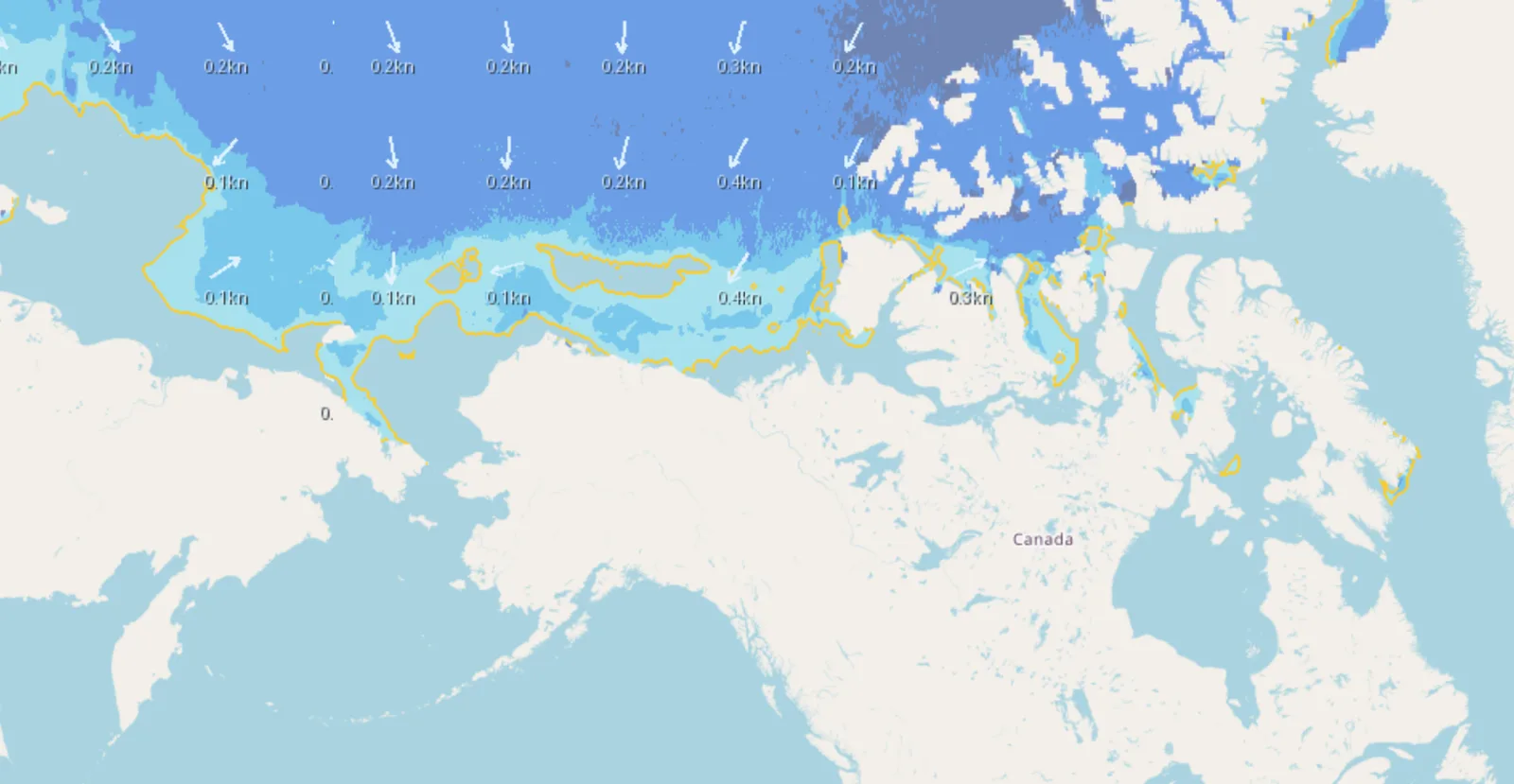 The sea-ice analysis this week: concentration bands, the modeled ice edge in yellow, and drift vectors across the western Arctic. The lane where the 1871 fleet was lost runs along the northwest Alaska coast, upper left.
I sail British Columbia's coast, about as far from pack ice as a Canadian sailor can get. This week I still found myself asking whether the Northwest Passage is ice free — out loud, in a demo video — and the reason I care sits at the heart of why we built Vector Weather at all: on the water, what conditions are doing right now matters far less than what they will do while you're out in them. Nothing on the ocean teaches that lesson as brutally as sea ice.
Every August, a small fleet gathers at either end of the Passage — sailboats in Nome and Pond Inlet, expedition yachts, the occasional rower — all asking the same question: is it open this year? More of them come every season. They are exactly the small-crew, small-vessel sailors we build for, heading into the one place where a forecast of movement is the whole game.
So Vector Weather now shows Arctic sea ice on the Conditions Map: concentration bands, the modeled ice edge, and drift vectors showing where the ice is headed. Click any point for the exact concentration and drift, step the forecast forward to watch the picture change, or check ice conditions at every waypoint along a planned route. Ice never acts alone, and Vector Weather refuses to show it alone: the same chart combines sea-ice prediction with the wind and current forecasts that drive it, so you can see the northerly that will push the pack south and the current that will carry it into a channel before they meet your route. The data comes from the Copernicus Marine global ocean model, a daily satellite-assimilated analysis and forecast at roughly nine-kilometre resolution.
The question the demo asks is older than the satellites, and the Arctic gave its most famous answer in 1871, off a pair of headlands on the north coast of Alaska.
The Year the Wind Didn't Shift
In August of 1871, thirty-three whaling ships lay in a ribbon of open water between the pack ice and the shore, working bowheads in a lane that ran up past Icy Cape toward Point Belcher. It was a good season. The lane had opened the way it always did, and every captain in the fleet sailed by the rule generations of Arctic whalers had proven: late in the summer, the wind comes out of the east and drives the pack offshore. It always had.
The Iñupiat, who had watched that coast longer than anyone, told the captains this year would run differently — a bad ice year, they said; take the fleet and go. The captains held thirty years of the fleet's own experience against that advice. They stayed.
Then the wind reversed. A stationary high parked over northeast Siberia turned the normal pattern around, and instead of driving the pack out to sea, the wind began pressing it toward the beach. The lane thinned. The fleet started working south, racing to round the headlands before the ice reached the shore and closed the door behind them.
The ice won. By the end of August the pack had pinned the fleet in shoal water against the beach, some ships in barely four fathoms. On September 2 the ice caught and crushed the Comet — her crew watched it come through her sides. Others followed. The captains waited for the easterly that had always come, and it never came.
On September 14 they accepted it. The captains signed a joint letter of abandonment, and 1,219 people — crews, and some captains' wives and children — went over the side into open whaleboats. They rowed, sailed, and in places dragged those boats roughly seventy miles south along the edge of the ice to Icy Cape, where seven ships that had stayed south of the pack lay waiting. The seven cleared their decks, threw whaling gear and cargo overboard, and took every single person aboard.
Every one of the 1,219 survived. The ice took thirty-two ships, and the loss — over $1.6 million in 1871 dollars — broke New Bedford's whaling industry for good. In 2016, NOAA archaeologists found wreckage from the lost fleet still lying along that coast.
We no longer hunt whales commercially, and that is a good thing. The bowhead has spent the years since rebuilding its numbers, and the hunt survives only as Indigenous cultural and subsistence practice: the Iñupiat still take bowhead from small boats along that same coast, as they did for centuries before the fleet arrived and have every year since it left. The sea kept the ships; the whales, and the people who understood that coast best, remain.
The same bet, made every season
Here is what makes 1871 a story about this summer rather than a story about the past: the warming Arctic has made the whalers' bet more tempting, and kept it just as dangerous. More of the Passage opens, more often, than at any point since people started keeping records — which is exactly why a sailboat with a crew of two now attempts a route that once beset entire national expeditions. But the ice that remains still moves the way it always has. It rides the wind at a few percent of wind speed, it rides the current beneath it, and when a blow sets it against a coast it can seal a headland in hours — faster than a small vessel can clear it. Less ice in the Arctic means more open lanes; it also means looser, more mobile ice that closes those lanes with less warning.
The captains of 1871 sailed carefully and knew their trade. They navigated by climatology — what the wind usually does, what the ice did last year — because climatology was the only forecast they had, and they discounted the one source that held real predictive knowledge about that season. A skipper staging for the Passage today holds something those captains would have traded every ship in the fleet for: a daily, satellite-fed model of where the ice is and where wind and current will push it over the coming days. Open water shows you the present. The transit rides on the future — and the future is now available in advance.
That is the question Vector Weather's sea-ice analysis puts on the chart, and the one this week's demo asks of 2026's Northwest Passage: open this week — and staying open?
Sea-ice analysis shows concentration and drift; it leaves thickness, ridging, floe size, and your vessel's ice capability to you. Ice, official ice services, and your own judgment still hold the final word. They always did — ask the Iñupiat of 1871.